Welcome back, friends!
This is the beginning of a series of posts I will be committing to: Fun Fact Friday.
Here’s something you might not know about Tethered In Blood—the map of Aurelith started with a bag of rice.
Yes, really.
When I first began writing, I had a general sense of where the major villages were, based on temperatures, travel routes, and specialties, but translating that mental layout into a visual map was another story entirely.
After several frustrating attempts to sketch it out, my husband (a longtime gamer and DND campaign watcher) stepped in with a chaotic but brilliant solution: he tossed a handful of rice onto a sheet of paper and drew around it.
And… it worked.
Here's what it looked like:

Something about the randomness gave me the perfect organic layout I hadn’t been able to force into shape on my own. I began labeling the “rice villages,” connecting the dots with trade roads, forests, rivers, and landmarks. I even tried turning it into a digital map myself:
But after a few weeks of clunky tools and late-night tutorials, I finally admitted defeat—and reached out to a professional.
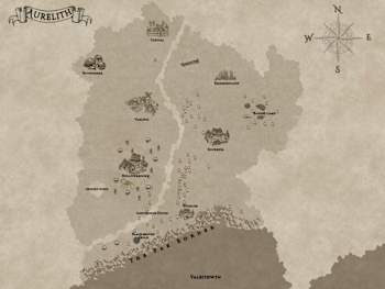
Saumya's Vision, @biblopolium on www.fiverr.com, brought Aurelith to life in ways I couldn’t have imagined. What started as rice on paper transformed into the breathtaking kingdom map that readers now explore alongside Eden and Oberon:

So if you’ve ever looked at the map in the front of Tethered In Blood and thought it felt real, now you know: it was grown from imagination… and grains of rice.
Happy Friday, and thank you for wandering The Kingdom of Aurelith with me.
—H. L. Rillon